


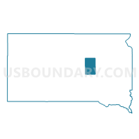
VTD-precinct 10 - SpringLake-BatesTwp, Hand County, South Dakota
About
Outline

Summary
| Unique Area Identifier | 667351 |
| Name | VTD-precinct 10 - SpringLake-BatesTwp |
| County | Hand County |
| State | South Dakota |
| Area (square miles) | 72.22 |
| Land Area (square miles) | 71.10 |
| Water Area (square miles) | 1.13 |
| % of Land Area | 98.44 |
| % of Water Area | 1.56 |
| Latitude of the Internal Point | 44.24663620 |
| Longtitude of the Internal Point | -98.82108970 |
Maps

Graphs
Select a template below for downloading or customizing gragh for VTD-precinct 10 - SpringLake-BatesTwp, Hand County, South Dakota


Neighbors
Neighoring Voting District (by Name) Neighboring Voting District on the Map
- VTD-precinct 1, Buffalo County, SD
- VTD-precinct 12, Beadle County, SD
- VTD-precinct 5, Jerauld County, SD
- VTD-precinct 6 - York-StLawrence-Pearl-HilandTwp, Hand County, SD
- VTD-precinct 7 - Gilbert-Grand-Hulbert-RoseHillTwp, Hand County, SD
- VTD-precinct 9 - Logn-Glndl-Ohio-Mndmn-PlsantVaeyTwp, Hand County, SD
Top 10 Neighboring County Subdivision (by Population) Neighboring County Subdivision on the Map
- Ohio township, Hand County, SD (106)
- North Buffalo UT, Buffalo County, SD (89)
- Bates township, Hand County, SD (43)
- Burr Oak township, Beadle County, SD (43)
- Hiland township, Hand County, SD (34)
- Rose Hill township, Hand County, SD (34)
- Sand Creek township, Beadle County, SD (26)
- Spring Lake township, Hand County, SD (24)
- Pleasant Valley township, Hand County, SD (23)
- Harmony township, Jerauld County, SD (22)
Top 10 Neighboring Unified School District (by Population) Neighboring Unified School District on the Map
- Miller Area School District 29-4, SD (3,107)
- Wessington Springs School District 36-2, SD (1,884)
- Wolsey-Wessington School District 02-6, SD (1,257)
Top 10 Neighboring State Legislative District Lower Chamber (by Population) Neighboring State Legislative District Lower Chamber on the Map
Top 10 Neighboring State Legislative District Upper Chamber (by Population) Neighboring State Legislative District Upper Chamber on the Map
Top 10 Neighboring 111th Congressional District (by Population) Neighboring 111th Congressional District on the Map
Top 10 Neighboring Census Tract (by Population) Neighboring Census Tract on the Map
- Census Tract 9741, Jerauld County, SD (2,071)
- Census Tract 9567, Beadle County, SD (1,922)
- Census Tract 9402, Buffalo County, SD (1,912)
- Census Tract 9756, Hand County, SD (1,556)